River Hipper’s Hidden Wildlife and Fish

Don Catchment Rivers Trust, with the support and advice from Derbyshire Council, Chesterfield Council, Environment Agency and the Wild Trout Trust recently embarked on a project to improve the River Hipper as it runs through Somersall Park, Chesterfield for wildlife and park users through the introduction of ‘woody debris’.

This project was fully-funded by the Environment Agency’s Fishery Improvement Program (FIP) which sees fees from rod licences reinvested to generate positive outcomes for anglers and fish stocks through projects such as this one which also included the design and installation of an interpretation board to inform park users of the work.

The River Hipper starts life as the Hipper Sick on Beeley Moor, high above Chesterfield. The river is a typical small, rain-fed Derbyshire stream, which passes through Holymoorside village before entering Chesterfield and flowing into the River Rother near Horns Bridge Roundabout.

It has a semi-natural feel to it however, this and many other stretches have been modified through straightening and the construction of barriers (weirs), restricting many of the natural river processes that would otherwise occur. In addition, the practice of removing windblown trees or branches from the river channel in public parks limits its ability form structurally-diverse habitats. 

What is woody debris?

Woody debris is any woody plant material that has entered the river channel. It can range from twigs caught in a tree’s root system to whole large trees that have fallen into the river.

Wood that has fallen into the channel is often tidied up and removed as it is thought to look “unsightly” or can snag the fishing lines of anglers. They can also cause problems when swept up against bridges or culverts when blockages cause flooding. 

Naturally, woody debris would be abundant and a very important part of the river ecosystem, so we now replicate this feature in a safe manner by carefully anchoring pieces of wood in place with metal fixings– as pictured. Appropriate consents from local agencies are also required to ensure work does not increase flood risk.

Benefits of woody debris?

The introduction of woody debris to the river will:

  • Creates bends, pools and riffles in rivers – important aspects of a heathy river (as pictured).
  • Promotes ‘sediment sorting’ – different plants and animals like different sizes of rock and sands
    •  e.g. burrowing mayflies like sand whereas flat-headed mayflies prefer flat stones and trout like to spawn in gravels.
  • Provides a ‘home’ for fish and other life
    • A place for them to hide from predators such as heron or kingfisher giving them a fair chance to escape – balancing predator-prey relationships.
    • When the river floods – provide somewhere to hide so they don’t get washed downstream
  • Traps leaves, twigs and encourages a biofilm (algea and bacteria) to form – food for insects that other invertebrates.
  • ‘Cleans’ rivers
    • Speeds up flow to clean gravel meaning more oxygen will flow over eggs in fish nests (redds) and greater hatching success.
    • Takes fine bits of dirt out of the water and deposits behind debris meaning water is clearer

Heritage Walks: Sheffield – Industrial Sheffield

The Don Valley Way has several heritage walks. In this series of blogs we are going to explore the walks and the fantastic features that can be seen along them.

This is a short walk around the once heavily industrialised area of North Sheffield. The walk is 1.6 miles/ 2.6km, and is completely paved. The area is well covered by public transport including busses and the super tram. Click here to see the Don Valley Way webpage for this walk.

The walk starts at Kelham Island. Kelham Island is not actually an Island at all. The land was man made to create a goit to help power a corn mill situated at Millsands near Lady’s Bridge. The Island was named after the town’s former armourer, Kelham Homer who set up a grounding workshop in 1637.

Kelham Island Museum

You can regularly see kingfishers on the section of the walk that follows the Upper Don Trail. For more information on the Upper Don Trail click here. Further along on the right a small rectangular Colum can be seen. This is a memorial commemorating the people who died in the great Sheffield flood 1864. Due to the expansion of Sheffield, a better water supply was required. To do this a dam was constructed to create a reservoir in the hills above the city. Dale Dike is a tributary of the Loxley, and was the river selected for the construction of the dam. Unfortunately Dale Dike Dam failed as the reservoir was filling for the first time, late at night on the 11th March 1864 causing a huge wave to sweep through the city, carrying 650 million gallons of water. The monument reads the 12th March as the wave didn’t hit the city until the early hours of the next day. At least 240 people lost their lives in the flood.

Great Sheffield Flood memorial

The first industrial use of waterpower in the town was along the section known as Millsands. The Weir in the area helped raise a head of water to help power the mill but causes a barrier for fish wanting to move upstream. The concrete structure that can be seen on the weir from Lady’s Bridge is designed to create a deeper channel of water which allows fish to pass upstream. Lady’s bridge is the oldest crossing in Sheffield. The bridge was named after the Chapel of our Blessed Lady which stood at the south East end of the Bridge. This is one of very few bridges to have survived the great Sheffield flood intact.

The weir seen from Lady’s Bridge and the Fish Easement

Further along the walk you will come to Mobray Street. There are several former industrial buildings in this section. Sheffield is best known for its cutlery and steel works, but the damage to the health of the workers shortened lives considerably. In 1844 Fredric Engals wrote a report which states, “by far the most unwholesome work is the grinding of knife blades and forks, which especially when done with a dry stone entails certain early death. The unwholesomeness of this work lies in part with the bent posture, in which chest and stomach are cramped but especially in the quantity of sharp edged metal dust particles freed in the cutting, which fills the atmosphere and are nesscserily inhaled.” The life expectancy of dry grinders was only 35 and the wet grinders was only 10 years longer.

Sculpture next to Bridgehouses Bridge showing the areas knife making history

Along Burton Road there is an old arch painted yellow on the right hand side. There is an image of a horse shoe in the keystone to represent the underside of a horses hoof rather than good luck. The building was once part of the Clarence works. It’s now used as the Yellow Arch Studios, where many Famous Sheffield Musicians hare recorded, including the Arctic Monkeys, Jarvis Cocker, Richard Hawley and more recently Blossoms.

Further along the walk you will come to the grade two listed Ball Street Bridge. Originally built in 1856, then rebuilt in 1864 due to the great Sheffield flood, it was widened in 1900. At the far side of the bridge you can see another grade two listed structure, Kelham Island Weir. It is one of the largest weirs in the city and originally drove Kelham Wheel which powered a cutler’s wheel, a silk mill and then a cotton mill. The weir serves no purpose now, but is unfortunately a barrier to fish moving through Sheffield. The concrete beam that can be seen across the weir creates a deeper channel for fish such as Atlantic Salmon to ascend the weir. As the weir is grade two listing, it unthinkable to install a technical fish pass such as the ones seen at Brightside and Meadowhall as this could damage the weir and remove part of Sheffield’s industrial history. The disadvantages of these less invasive easements are that passage cannot be assured 100% of the time where as they can be in other fish passes.

Kelham Island Weir

To learn more about this area of Sheffield and the famous Elephant Lizzy, you should listen to our audio guide as you walk recorded by Community Engagement Officer and resident of Sheffield Sally Hyslop. To listen to the audio guide download the Don Valley Way app or stream it from the walks page of the Don Valley Way website.

Click here for the Don Valley Way Website

Click here for the Industrial Sheffield Walk

Click here to download the Don Valley Way app on Android devices

Click here to download the Don Valley Way app on IOS and Apple devices

By Project Assistant Anthony Cox

Heritage Walks: Mexborough – Sappers, Poets and Pirates

The Don Valley way has several heritage walks. In this series of blogs we are going to explore these walks and the fantastic features that can be seen on them.

We’re going to start with the walk in Mexborough titled Sappers, Poets and Pirates. The walk will explore the evolution of Mexborough from a small Iron Age settlement to the industrialised town fuelled by the connections of the canal. The walk is 5.4Km/ 3.4 miles and will take roughly 2 hours. The terrain is mostly paved and includes some road crossings. Part of the walk is on unpaved footpaths and tow paths which are well maintained. It is a circular walk that starts and finishes at the ferryboat Inn near the train station. Click here to see the Don Valley Way page for this walk.

The walk starts at the Ferry Boat pub which is the oldest pub in Mexborough dating back to 1442. It was named this after the workers who used it whom ran a ferry to cross the River Don. It was a favourite drinking spot of the Poet Laureate Ted Hughes.

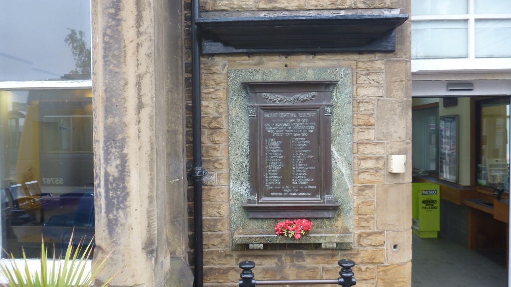
Castle Hills Park is the second point on the walk. It contains Mexborough’s war memorial payed for by local collieries in honour of Sapper W Hacket who was awarded the Victoria Cross. The memorial was originally built to the right side of the doors to Mexborough council rooms at Market Hall. Towards the end of the 20th Century the Hall was sold and the memorial was moved to its new home at Castle Hills Park where it can be seen today. A second memorial for Mexborough’s railway workers can also be seen on the route outside the Train Station.

The park is named Castle Hill as it is the location of the Mott and Bailey castle, Mexborough Castle. Mott and Bailey castles were introduced by the Normans after they concurred England in 1066. They comprised a large earth mound known as a Mott with a wooden palisade at the top surrounding a stone or timber tower. In most examples an embanked enclosure containing additional buildings (the Bailey) joined the Mott. These castles acted as garrison forts during offensive military operations, strong holds and as aristocratic residences. These castles were built from the 11th to the 13th century until they were superseded by other types of castle. In the 11th century the castle was the manor of Robert de Busli Lord of Tickhill.

Mexborough was an ideal spot for early settlers. The Don would have supplied clean water and a ready supply of fish. The surrounding land would have been perfect for grazing livestock and provided clay for pots as well as wood and stone for building. After the departure of the romans, Mexborough was discovered by Saxon’s from whom id derives its name. Mex from the name of the Chieftain Mjukr (pronounced me-ock) and borough which describes a fortification which was thought to have been located at the sight of Castle Hill Park.

Ted Hughes was a pupil in Mexborough in the 1940’s where he was first introduced to poetry. His school can be seen on the route off College Road. His first poems and stories were published in the Schools magazine, The Don and Dearne. The school can be seen at point five on the walk. You will also pass 75 Main Street, the childhood home of Ted Hughes which has a blue plaque above the door commemorating this.

The walk continues along a stretch of the River off Meadow Way. This area was used by small boats carrying valuable cargo from Sheffield. The route had to be navigated in one day as boats moored in this area were regularly targeted by pirates. Boats often ran aground on this section as the waters were very shallow.

To learn more about this heritage Walk you should try it! You can listen to our audio guide online or on the Don Valley Way App, found on the App Store and Google Play!

Click here for the App on Android devices.

Click here for the App on Apple/ iOS devices.

Click here for the Mexborough page of the Don Valley Way Website.

Click here for the Don Valley Way Website.

By Project Assistant Anthony Cox

A photographer’s tale

In this guest blog we hear from local photographer John Grimbley, who has been documenting the recovery of the industrial riverside along the river Rother.

This is a photographer’s tale of lockdown, intrigue and exploration in the Rother Valley. From March 2020, when travel was curtailed through COVID 19, most of my photography needed to be closer to home. This was necessary to keep fit and avoid going ‘stir crazy!’ I stumbled on a patch of land bordering onto Rother Valley Country Park, once part of the Brookhouse Colliery and Coking Plant, until the 1980’s when it closed.

It was once an area in which ‘open-cast’ mining was also undertaken and, although the area is still heavily polluted, if you take a closer look, there is life! Nature has this ability to bounce back and there really is a lot to see: re-colonising wild flowers in the old ‘pit spoil’ and, on a few occasions, I have even had sightings of roe deer, red fox and tawny owl!

 In the spring and summer, there is a profusion of wildflowers; weld, a variety of thistles, oxeye daisy, hawkweed, musk mallow, common birdsfoot trefoil, dog rose and even honeysuckle; along with tree’s such as alder, birch, oak and hawthorn. The area buzzes with a variety of insects.

There is a lot of pollution, with drainage of ochre from the old colliery shafts, which eventually enters Pigeon Bridge Brooke, before finding it’s way into the River Rother.

I have started to undertake a ‘documentary’ record of this area to see how things develop over the years. My initial plan is photograph an Ordnance Survey Map ‘One Grid Square’ of ostensibly unattractive land-its potential for protecting and encouraging wildlife and understanding how the legacy of our industrial activity can mitigated.

Many people pass by whilst I’m taking my photographs (often I’m kneeling or wading in mud!), but few stop, probably thinking the area is a bit of a mess (or this camera guy looks a bit weird!) and quickly walk by. To the casual by passer, this area shows little interest, but on inspection of the ‘spoil’ in the area there is significant evidence of our industrial history and also the potential for environmental improvement.

I would be really keen to speak to anyone who has knowledge of this patch of land – If you do please get in touch: john@johngrimbley.plus.com